The Losses of the Valserine
Discovering the Losses of the Valserine: a natural treasure of Valserhône
Why are the Losses of the Valserine so fascinating?
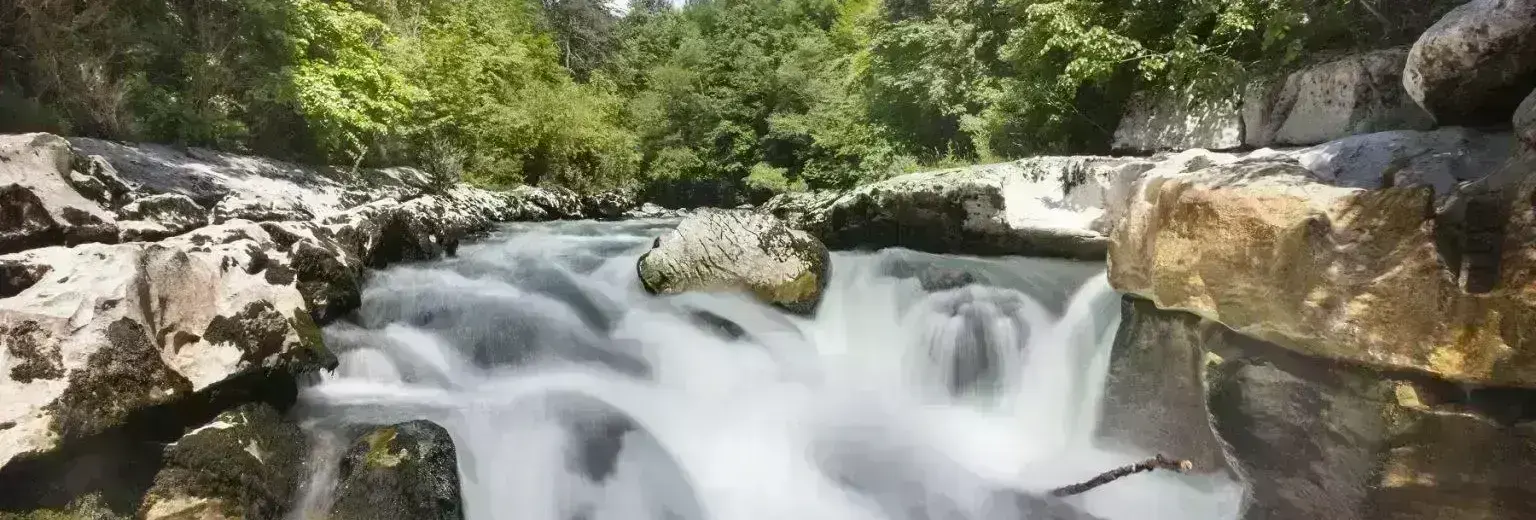
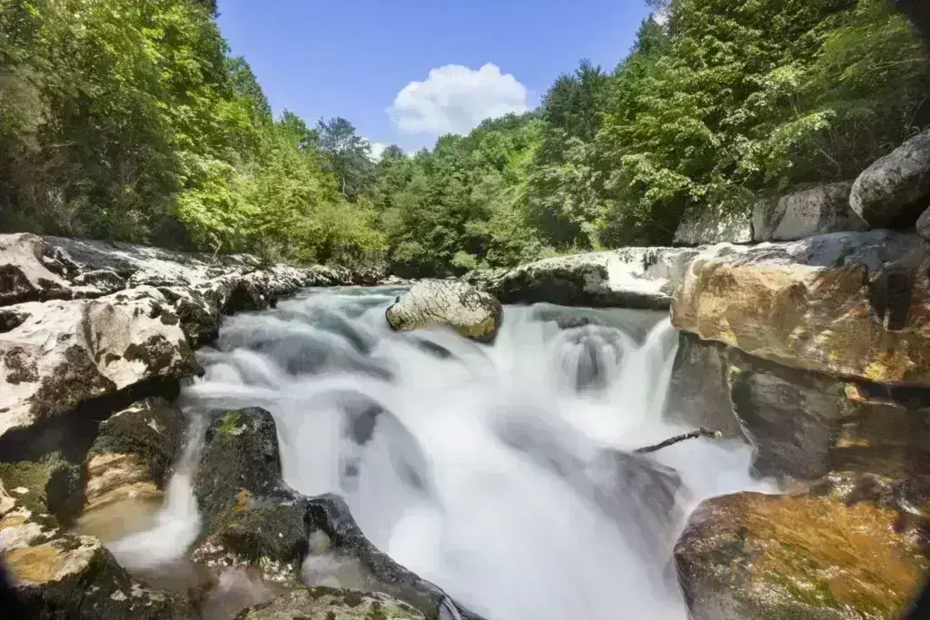
The Losses of the Valserine refers to a spectacular karst canyon on the Valserine River, near Bellegarde-sur-Valserine (now Valserhône), in the Ain department. When you observe the site, the water seems to disappear into narrow crevices only to reappear further downstream, hence the name “Losses” (losses). In reality, the river plunges between limestone walls, forming potholes, sinkholes, and narrow canyons.
This spectacular natural phenomenon is situated within a protected environment: the Valserine was the first French river to be designated a “Wild River” for the quality of its water and the preservation of its environment. The valley, with its gorges, cliffs, and forested landscapes, offers an ideal setting for lovers of nature, geology, hiking, and local history. The Valserine Gorges are one of the must-see sites for exploring the Jura Mountains.
An accessible location: how to get there and start your hike
There are several starting points for accessing the Valserine Gorges. You can park in the car park along the D1084, reach the site from the old tramway track (at the Rougeland locality), or start from the town centre of Valserhône/Bellegarde. This last option allows you to easily connect the town to the river and the gorges, while enjoying a gradual walk into nature.
One of the easiest routes follows a marked trail, indicated by red and white blazes, which descends to the canyon. Allow approximately 5 km round trip and 2 hours for the “leisurely walk”. This route is well-suited for a first visit to the Valserine Gorges in Valserhône, with a reasonable elevation gain and well-marked sections.
The trail then follows the Valserine River, occasionally crossing metal footbridges or bridges, and offers several viewpoints overlooking the canyons. Visitors can enjoy various perspectives on the river, the limestone cliffs, and the famous sinkholes where the river seems to disappear underground.
For safety reasons, some sections may be closed, particularly between the Valserine riverbank parking area (Rue Louis Dumont) and the section between the footbridges and the Métral dam. It is therefore strongly recommended to check access conditions with the tourist office or the information panels on site before setting out.
Two hikes to discover the Valserine Sinkholes
Depending on your time and energy level, several loops are possible. Some visitors prefer a simple stroll along the riverbanks, while others opt for a longer hike that combines gorges, an old tramway line, and panoramic views of the valley.
Easy walk (from D1084 or Valserhône town center)
Time: Approximately 5 km, 2 hours round trip
Difficulty: Easy, accessible
Interest: Discover the canyon, the water disappearing into the rock, the potholes and sinkholes, ideal for families.
Longer loop / moderate hike
Time: Up to 13 km, approximately 4 to 5 hours, moderate elevation gain
Difficulty: Medium/moderate
Interest: Discover the industrial history (tram, dam, old factories), more scenery, and a long stretch of the Valserine River.
What you’ll see along the way
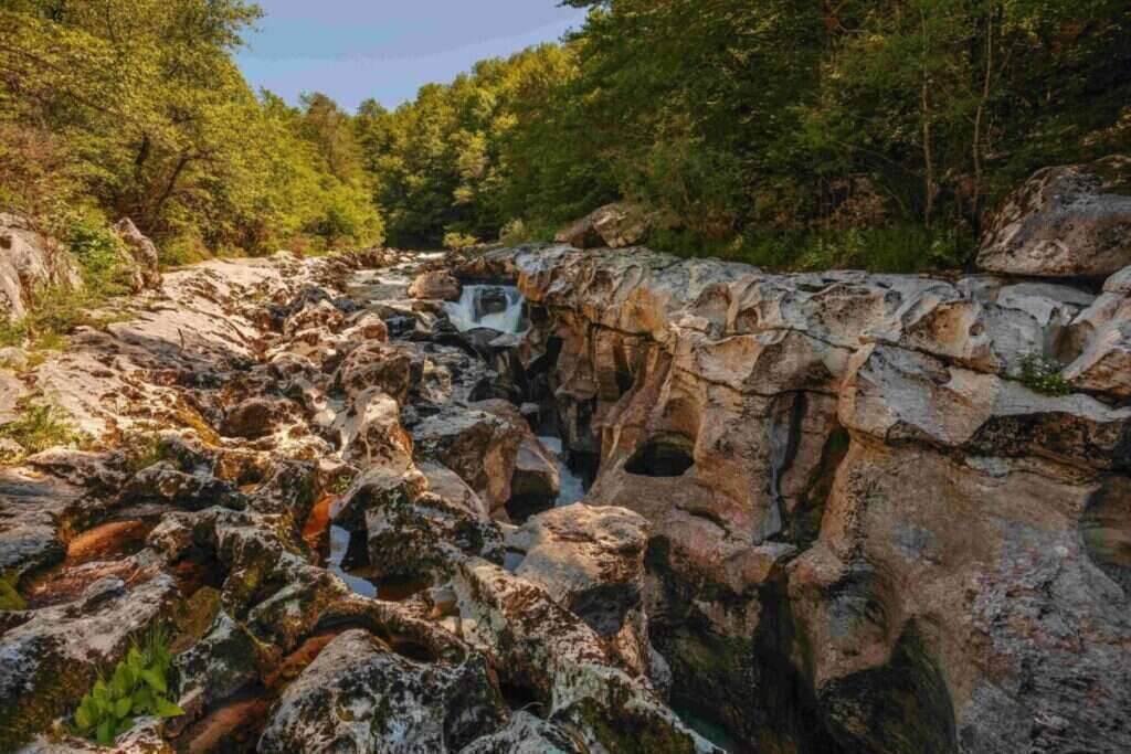
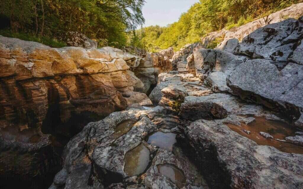
Throughout the route, hikers alternate between sections in the forest and stretches along the riverbank. The heart of the hike remains the canyon: limestone cliffs, narrow gorges, potholes, and sinkholes, where the Valserine River’s disappearing streams give the impression that the water vanishes.
You’ll also encounter footbridges and bridges, such as the Pont des Oulles, which allow you to cross the river and observe the gorges from different perspectives. These crossings enhance the feeling of walking through a small labyrinth of limestone canyons.
Traces of the industrial past are visible in several places: an old tram line, structures related to the dam or the diversion of the river, and reminders of the activities of Bellegarde-sur-Valserine. The river has long been a source of energy for the town and its factories.
The combination of the forest, the cliffs, and the sound of the water makes it an ideal place for those seeking peace, coolness, and direct contact with the outdoors.
Numerous online reviews highlight the appeal of the site: many describe it as a “magnificent walk,” a “relaxing and rejuvenating” place, provided you wear good walking shoes and take the time to explore the different viewpoints.
Nature, geology, and history
Geology and landscape
Nature, geology, and history
Geology and landscape
The phenomenon of “losses” perfectly illustrates the limestone relief of the Massif.
of the Jura Mountains. The water gradually carves through the rock, forming potholes, chasms, and narrow canyons into which the river plunges only to reappear further downstream. This labyrinthine aspect of limestone canyons contributes to the site’s very distinctive character.
In places, the cliffs reach several tens of meters in height. The visual effect is striking. The light plays with the color of the water and the light hue of the limestone, offering a remarkable contrast for photography enthusiasts.
The Valserine River itself flows for approximately 48 km between its source in the Haut-Jura and its confluence with the Rhône. It traverses diverse landscapes: mountains, forests, valleys, gorges, and plains. The Pertes de la Valserine (Valserine Losses) site is the most spectacular section of this waterway, where geology and hydrology combine to offer a natural spectacle unique in France.
A Preserved Natural Environment
The Valserine River has been awarded the “Wild River” label, a designation that guarantees the quality of its water and the preservation of its ecosystem. The valley is also classified as a Sensitive Natural Area, which entails specific management practices to balance public access with site protection.
These designations encourage gentle and respectful tourism, limit large-scale development, and raise visitors’ awareness of the fragility of this environment. Visiting the Pertes de la Valserine (Valserine Losses) means admiring a spectacular landscape while contributing, through responsible behavior, to its preservation.
History and Human Heritage
Beyond its geological features, the Valserine is closely linked to the history of Bellegarde and Valserhône. The river’s water long powered local industry and energy production. Dams, factories, and diversions of the waterway are reminders of this industrial past, on the border between the Ain and Haute-Savoie departments.
The Valserine Valley has also frequently served as a border: between France and Savoy, a free trade zone, and a demarcation line during the Second World War. Walking along its banks, therefore, also means traversing a landscape marked by history and population movements.
Infrastructure such as the old tram line, the viaduct, and the tram bridge still bear witness to this period when the river was central to trade and the development of Bellegarde. Today, these vestiges blend into a much more peaceful setting, geared towards hiking and nature tourism.
Practical advice for visiting the Pertes de la Valserine (Valserine Losses)
Suitable footwear: the path is sometimes rocky and slightly slippery, especially near the water. Good hiking boots are strongly recommended, rather than lightweight sneakers.
Safety: near the gorges, hold children’s hands and avoid getting too close to the edge, especially when the flow is strong (floods, heavy rain). Some sections may be temporarily closed for safety reasons.
Family-friendly: The shortest walk is accessible to families accustomed to hiking, but caution is advised with young children. Dogs are generally welcome, provided they are kept on a leash.
When to go? Spring, summer, or early autumn are ideal, when the path is passable and the scenery is at its most pleasant. During periods of high water, some areas may be dangerous or closed.
Planning the return trip: Depending on the chosen route, the return journey may be along the riverbanks or the old tram line. Check for any detours before setting off and allow enough time to fully enjoy this exceptional site.
Some limitations & points to know before setting off
Closed or diverted sections: Some parts of the trail, particularly the section between certain riverbanks and the dam, may be closed. It is essential to check the latest information at the tourist office or on the information boards.
Accessibility: The terrain is not suitable for strollers or wheelchairs. Steps, roots, stones, and narrow passages make the Perte de Valserine difficult to access for people with reduced mobility.
Weather: During periods of heavy rain, the path can become slippery and the river impressive. These conditions are not recommended for young children. It is best to choose a dry day to enjoy the site in peace and quiet.
Equipment: Bring essential equipment: hiking boots, water, a windbreaker or rain jacket depending on the season. Be careful on the bridges and footbridges, and do not venture too close to the edge of the cliffs.